
Examining EPOS & RTK Systems in Robotic Mowers
The terms EPOS and RTK must have come up frequently during your research into a wireless or wire-free robotic lawn mower. A wireless lawn mower uses coordinates from GNSS/GPS satellites to know its exact position and determine its boundaries. Traditional GPS systems can only provide location accuracy of 2-3 meters or more. With such low accuracy, it is impossible for a robotic lawn mower to mow any lawn accurately, as it could make the difference between whether the mower is on the grass or in the pool.
Understanding the RTK/GNSS System
Most wireless mowers rely on technology called RTK/GNSS, which enables them to locate themselves with an accuracy of 1-3 centimeters. With this high level of accuracy, robotic lawn mowers can very precisely know their boundaries and mow your lawn efficiently.
RTK (Real-Time Kinematic) systems have been around for some time and have many use cases. The technology is commonly used for applications such as land/site surveys and autonomous vehicles. GNSS is a collective term for constellations of satellites from multiple countries. GNSS stands for Global Navigation Satellite System. As the name suggests, it is a general term for any satellite constellation that provides global or regional positioning, navigation, and timing (PNT) services. The different constellations that comprise GNSS are Galileo (EU), GPS (USA), GLONASS (Russia), and BeiDou (China). With multiple constellations, it is easier to get maximum visibility of satellites. The more satellites that are visible, the better the location accuracy.
What is the primary challenge in location determination using satellites?
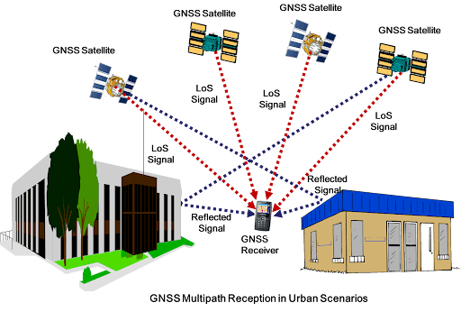
Satellites transmit signals that have to travel very long distances and pass through different layers of our atmosphere. As the signal travels, it can induce some distortion, delay, and another common issue called multipath propagation. Multipath propagation occurs when the satellite signal bounces off multiple surfaces such as buildings, walls, trees, etc., and the same signal reaches the GNSS receiver at different times. Due to all these issues, location accuracy can be compromised when the GNSS receiver is constantly moving.
What makes RTK systems so accurate?
The RTK system leverages a fixed location GNSS receiver and uses it as a reference to get corrected signals to the mobile GNSS receiver. But how is that any different? Let's dive in. The fixed GNSS receiver in the RTK system is usually called a "Base Station" or "Reference Station". The moving device that needs the accurate signal is called the "Rover". When the base station is installed in a fixed position, over time, as it collects more and more data from the GNSS system, it is able to estimate the effects of the atmosphere and other variables. Using this data, it estimates its own location to an accuracy of a centimeter. As the base station sits in the same location, this estimation gets better and better, and the base station can then easily estimate the deviation of location from the satellites as the signal is received and its actual location.
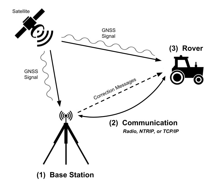
The "Rover" or the moving GNSS target cannot do the same thing as the base station because it is constantly moving. So to get an accurate location, the rover communicates with the base station continuously and reports the GNSS signals it receives. The base station uses its own data to determine the deviation in location that the rover might have and communicates back to the rover with the corrections needed to improve the rover's location to an accuracy of a centimeter. All this is done in real time, hence the name Real-Time Kinematic (RTK).
This way, the rover and the base station continuously communicate with each other, enabling the rover to estimate its location with a high level of accuracy. In the case of robotic lawn mowers, the mower is the rover, and the reference station is the fixed base station.
Then, what is EPOS?
The process explained in the section above is the general functionality of how an RTK system works. The implementation of this can be done in different ways. For example, the communication between the rover and the base station can be done directly using a radio standard or through the internet (where the reference station can be miles away). Another part of the implementation is the way the satellite signals are filtered, combined, and used for improving location accuracy, or even the way the system compensates for location when satellite signals are missing. Implementation practices can define the reliability and accuracy of the system in challenging scenarios, and each manufacturer may have their own algorithms and ways of implementing the system.
EPOS, which stands for Exact Positioning Operating System, is a term that the manufacturer Husqvarna uses to define their implementation of the RTK system. The term EPOS is specifically used for Husqvarna RTK systems and is not an industry-standard term. Similarly, Kress, another wireless robotic mower manufacturer, refers to their system as "RTKn" or "RTK to the power of network," as their implementation is completely different from Husqvarna's.
Will EPOS or RTK mower work for my yard?
Now that we have a good understanding of how RTK works, what EPOS is, and the challenges that need to be overcome for a good RTK system, let's understand the aspects that are important in considering the system for a home.
What can impact the RTK system's functionality?
There are a few things that are very important to consider for optimal performance of an RTK system
1. The Reference Station (or) Base Station should be seeing all the satellites that the mower might see when it is working
The reference station should see all satellites that the mower is seeing, or in other words, the number of common satellites seen by the mower and the reference station should be as high as possible. This is important because if the mower is seeing satellites that the reference station is not seeing, then the reference station will not be able to send the necessary correction signals to the mower. This disables the mower from identifying its location accurately and can cause the mower to stall.
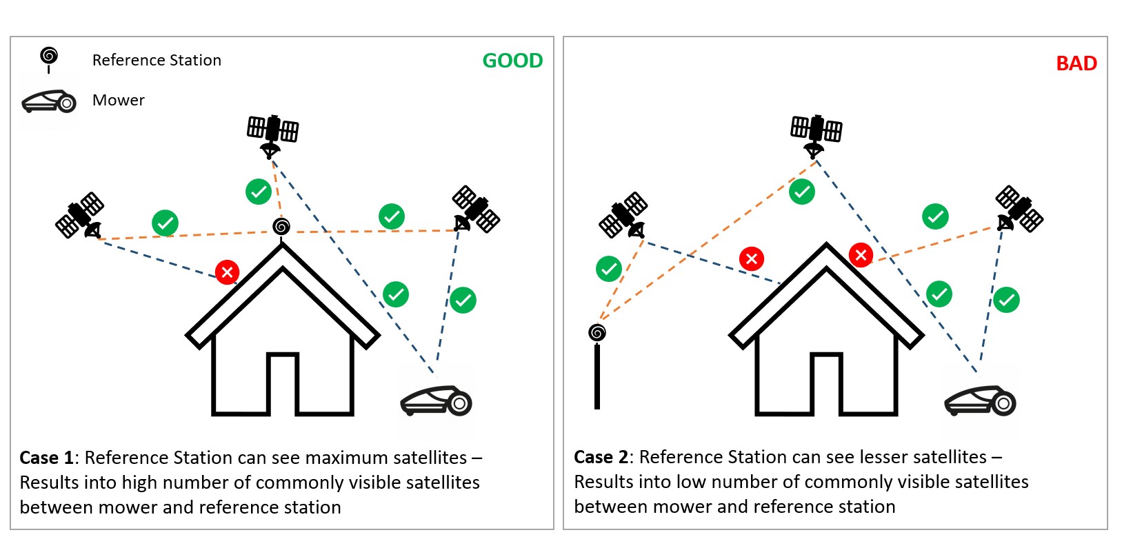
It is therefore very important to determine the optimal location to install the reference station for a given property. At SmartDots, we help all our customers to identify the optimal location and guide them through the process.
2. The mower should be able to see open sky in all directions for majority of the time when mowing in the yard
The GNSS signal can get heavily attenuated or even lost when it has to pass through multiple objects, trees, buildings, etc. This makes it important that the mower has maximum visibility to the sky as much as possible when it is mowing. Manufacturers implement some fallback plans for brief loss of signal using built-in IMU sensors and directional sensors to estimate the location of the mower when the signal gets lost. This estimation can only provide a limited amount of relief during signal loss from GNSS, and if the signal is not retrieved for an extended period, the mower may just stall and require manual intervention.
Trees with heavy and dense canopies can be a challenge and need to be accounted for when an RTK system is being considered. Some manufacturers also offer another fallback system using vision (VSLAM) or LiDAR, where the loss of RTK signal can be sustained for a longer time.
3. Communication between the reference station and the mower should be reliable
The final consideration is whether the mower will be able to communicate reliably with the reference station. This is where the system design, mower/manufacturer selection, etc. can become important. Typically in the US, the reference station and the mower communicate using the 900-915MHz radio channel. For typical yards, this frequency can work well without the need for line of sight between the mower and the base station. Although most manufacturers use the same frequency, the signal power and protocol used for implementation can impact coverage range. When the yard is very large (>2-3 acres), it is important to evaluate whether a system that supports repeater reference stations should be leveraged for optimal coverage.
So, will EPOS/RTK work for my yard?
The answer lies in evaluating the scenarios mentioned above. If you can evaluate an optimal location for the installation of the reference station, have a fairly open yard with minimal trees, and do not have narrow passages with walls or buildings on both sides, then EPOS may be a good solution for you.
At SmartDots, we are always ready to help our customers determine the best solution for their yard. If you are not sure whether a wireless system can work for your yard, please reach out to us at info@smart-dots.com, and we will be happy to help.