EPOS: Searching for Satellites
The Husqvarna EPOS mowers work on the RTK technology that relies heavily on GPS/GNSS signals to be able to provide accurate location of the mowers. The RTK system contains 3 main components - The Reference Station, Mower and the GNSS satellites. The reference station and the mower are constantly able to locate themselves using the satellites. The reference station then sends correction signals to the mower to help it update its location to an accuracy of a centimeter.
In this process, the mower and the reference station constantly need to have visibility to the sky to be able to receive GPS signal. There may be certain instances when the reference station or mower may not be able to get GPS signal,
- The satellites are constantly moving and it is possible that there may be certain time instances during the day when the reference station and/or the mower may not have visibility to the minimum number of satellites and a "Searching for Satellite" error may show up. Typically this is a self-correcting situation and once sufficient satellites are visible, the operation resumes.
- The mower is another component that is constantly moving. Depending on its installation layout, it is possible that it loses signal under canopy of a tree or near a tall structure/building. It is also possible that the transport path of the mower is defined such that it has to pass through areas where GPS signal is weak. In such instances the mower may show the error "Searching for Satellites" and stop operating until the signals are re-established.
Resolution:
This is a self-resolving error as long as it is a temporary loss of satellite signal. However if the issue is persistent in areas where GPS signal is perpetually weak (like under tree canopies, close to structures/buildings etc), then the best way to resolve would be to remove objects that are causing the obstruction (trim tree branches, remove barriers etc) (or) create a "stay-out" zone in the areas so that the mower does not work in areas with poor GPS signal strength.
Another consideration to minimize loss of signal from GNSS satellites is to manage the mower's direction/pattern of mowing. See images below that explain this in more detail,
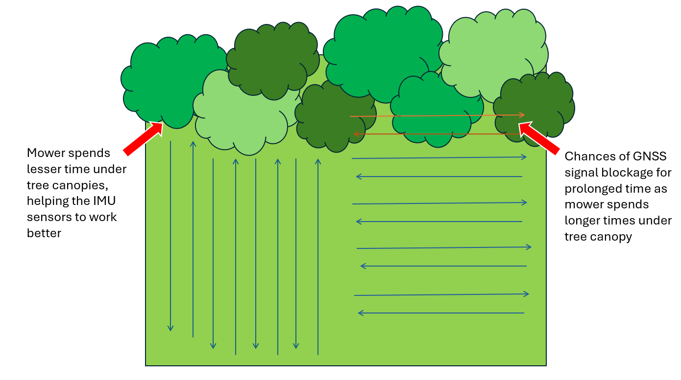
In the image above, on the left side, it shows the pattern of the mower going north and south. This way, the mower spends lesser time under the tree canopies and this enables the IMU sensors to compensate better for loss of signal from GNSS satellites for a smaller duration of time. But the example on the right shows a East-West mowing pattern, which will force the mower to spend longer time under the tree canopy and hence increasing the probability of losing GNSS signal for a longer time. The IMU sensors can only compensate for loss of GNSS signal for a certain period of time, after which the mower will not be able to accurately locate itself.
The same logic can also be applied for areas with tall buildings, walls and other obstacles that can impact GNSS signal.
Please reach us out at support@smart-dots.com in case you are having Satellite reception issues even in open spaces.